Now that we are about 75% of the way through the snow accumulation season, we have enough information to make predictions of water supply for the upcoming April–September 2025 season. A water report reader earlier this week suggested that I calculate probabilities of reaching average streamflow from where we currently stand (as of February 20). Thank you for the suggestion—here are the results!
A little background information
Let me first say the terms “water supply” and “natural streamflow” mean the same thing: the total amount of streamflow doled out to the river system by the watershed from snow, rain, and groundwater springs. Management such as reservoir storage and delivery and irrigation diversion determine the actual amount of streamflow in a reach of river at any given time, but natural flow is independent of management and is the finite amount of water we have to work with.
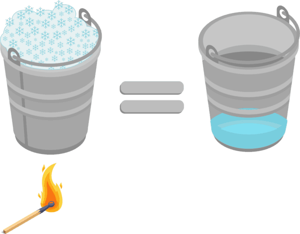
Second, the depth of snow on the ground does not determine water supply for the spring and summer. How much water is in the snow determines spring and summer water supply. That’s why I report snow water equivalent (SWE). SWE is the depth of water obtained from the snow if it were melted. For example, if I took my straight-sided pasta pot, filled it with snow, and then melted the snow, the depth of water in the pot would be the SWE. One foot of typical dry, mid-winter snow would melt to around 1 inch of water, whereas one foot of old, compacted snow late in the winter might have 4 inches or more of SWE in it.
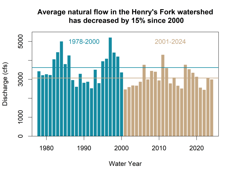
Third, remember that water supply at the watershed scale is 15% lower over the past 24 years than it was over the previous 23 (22% lower in the upper Henry’s Fork). So this year I am going to report my water supply predictions in comparison to 1978–2000 and 2001–2024 separately. It’s just getting to be apples-to-oranges to mix the two time periods together.
Can we get enough snow to have average water supply this summer?
From where we stand right now in snowpack, soil and aquifer conditions, and an increasing trend in summertime temperatures, here are our chances of getting enough snow between now and early April to reach the average water supply for 2001–2024 by subwatershed:
17% in the Teton River
11% in Fall River
Less than 1% in the upper Henry’s Fork (anywhere upstream of Ashton)
Across the whole watershed, we have an 8% chance of Mother Nature giving us the 2001–2024 water supply average. Regarding the upper Henry’s Fork, we would need to receive 12% more SWE (around 2 inches) between now and early April than the maximum on record to get to 2001–2024 average streamflow. This is highly unlikely but still theoretically possible, so I’ll give it a non-zero albeit small chance.
For folks with a deeper history in the watershed, let’s talk about our chances of achieving the 1978–2000 average. The probabilities of getting enough snow between now and early April to reach the 1978–2000 average streamflow are 3% for the Teton River and 0% for Fall River, the upper Henry’s Fork, and the watershed as a whole. In the upper Henry’s Fork, the Black Bear SnoTel station (on the Continental Divide between Big Springs and West Yellowstone) would need to get 34 more inches of SWE over the next six weeks to produce the 1978–2000 average streamflow. The record SWE accumulation over that six-week time period is 17 inches, achieved in 1989; hence the 0% chance. Remember, we’re talking inches of water in the snow—not inches of snowfall. That 34 inches of SWE would be around 25 feet of snowfall!
The bottom line is that the odds strongly favor natural summertime streamflow that is below the 2001–2024 average, and there is no chance of getting the 1978–2000 average. Right now, water supply is likely to be around 90% of the 2001–2024 average, pretty close to what we had in 2024. But that’s just the amount of water Mother Nature is giving us. Managing that water is the next step.
Is 90% of average water supply “enough”?
So, let’s say we get 90% of the 2001–2024 water supply this summer. Is that enough water? The answer depends on who you are and what you expect. For the scientific details justifying these assessments, please see HFF’s recently released 2024 technical report.
Irrigation water supply
If you are an irrigator, the news is good. There will very likely be adequate physical and administrative water supply for irrigators in the Henry’s Fork watershed. Island Park Reservoir, Henry’s Lake and Grassy Lake will all fill, and the upper Snake River reservoir system will either fill or come close enough to full that irrigators in the Henry’s Fork watershed will very likely receive their full storage allocation. Irrigation diversion in the watershed since 2001 is 23% lower than it was prior to that, so farmers have already made the adjustments necessary to maintain their operations with a lower water supply. No Island Park Reservoir water will need to be sent to American Falls this year, so water managers will be able to keep as much water in Island Park Reservoir as possible.
Island Park Reservoir level
If you recreate on Island Park Reservoir or fish the Henry’s Fork upstream of the reservoir, the news is also good. The reservoir will drop rapidly in July but will likely end the summer at 60,000 ac-ft (44% full), about where it has the past few years. That’s enough for season-long recreation on the reservoir and reasonable survival of kokanee and trout that migrate into the upper Henry’s Fork. Thanks to collaborative precision water management and modern irrigation infrastructure, end-of-season reservoir contents will likely be around 20,000 ac-ft more than we would have seen under pre-2018 management, providing benefits to water quality, fisheries, flat-water recreation, and irrigators.
Fishing between Island Park Dam and Pinehaven
If you spend most of your time fishing between Island Park Dam and Pinehaven, the news is not so good. Although anglers will no doubt find some good fishing in some locations at certain times of year and times of day, generally you can expect periods of high turbidity during mid- to late-summer, a few weeks of high outflow from the dam in July, high water temperatures in July and August, below-average trout numbers (except a good cohort of 2-year old fish coming from good winter flows in 2023/2024), and inconsistent hatches. Flow during late September and October will again be very low to store as much water in the reservoir as early as possible to maximize winter outflow for juvenile trout survival. All of these less-than-desirable outcomes are a function of warmer spring and summer temperatures and much lower water supply than we experienced in the 1970s–-1990s. Although none of us can cool the air or make more water, there are some large-scale infrastructure improvements and restoration actions that can offset warmer temperatures and lower water supply. Please read the technical report to learn more, including how HFF’s DIRTT plan can improve water quality and hatches.
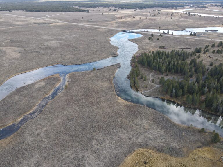
Fishing between Mesa Falls and St. Anthony
If you fish between Mesa Falls and St. Anthony, conditions will be good and very similar to those over the past few years, subject to weather conditions. Fish populations and hatches are stable and relatively independent of water supply in these river reaches, and I don’t anticipate any changes this summer. The only negative aspect may be low flows again in the fall as managers try to store as much water as possible in Island Park Reservoir to maximize winter outflow for juvenile trout survival on the Caldera.
Fishing downstream of St. Anthony
If you fish between St. Anthony and Parker, that reach will look very much like it has for the past five years. Flow at Parker will be held at the 350 cfs target for all of July and August and probably some of June and September, depending on weather. That target was set primarily to keep as much water in Island Park Reservoir as possible. Mid-summer fishing will generally be slow, but anglers in the know will catch some large brown trout in the fall after flows come up and water temperatures cool.
What is HFF doing?
Unfortunately, we can’t make more water. But we can monitor every drop, every day, everywhere and make that data available so water managers, irrigators, and recreationists across the watershed can best prepare and adapt accordingly.
Except for weekends and holidays, I write a short technical report that details our current and expected water situation. Read the Daily Water Report online or sign up to get it sent to your email inbox (bottom of the webpage).
We share regular river updates to our Facebook and Instagram It’s a great way for folks to stay up to date with the latest.
We attend every Henry’s Fork Drought Management Planning Committee meeting and bring our data to the table to advocate for solutions that are mutually beneficial to all river stakeholders—no matter what Mother Nature gives us.
We measure streamflow every week during the summer and every month or two during the winter at six key locations around the watershed to ensure water managers have the best available information to make decisions. Learn more here and see our water quantity website for up-to-the-hour data!
We are installing measurement stations to monitor the snow-to-flow pipeline in real-time across the Henry’s Fork and South Fork watersheds, courtesy of a $400,000 U.S. Bureau of Reclamation WaterSMART grant, to hone in our water supply predictions important for river and reservoir management.
The Henry’s Fork Drought Management Planning Committee (DMPC) met on Monday, November 24 to set this winter’s outflow and reservoir-fill strategy for Island Park Reservoir—an annual decision with implications for winter trout habitat in Box Canyon and the Ranch. Winter Outflow: What’s Coming on December 1 Beginning December 1, outflow from Island Park Dam will increase, bringing winter streamflow through Box Canyon to ~380 cfs from December through February*. That equates to 76% of Box
The Henry’s Fork Foundation (HFF) has become aware of, and is actively investigating, the recent drawdown of Silver Lake in Harriman State Park. The sudden lowering of the lake released a large amount of fine sediment downstream into Thurmon Creek and the Third Channel of the Henry’s Fork through the Ranch. HFF was not informed before Silver Lake was drawn down. Fortunately, our science team was already in Harriman State Park and responded immediately, documenting
The Henry’s Fork Foundation (HFF) has become aware of, and is actively investigating, the recent drawdown of Silver Lake in Harriman State Park. The sudden lowering of the lake released a large amount of fine sediment downstream into Thurmon Creek and the Third Channel of the Henry’s Fork through the Ranch. HFF was not informed before Silver Lake was drawn down. Fortunately, our science team was already in Harriman State Park and responded immediately, documenting
Guest Article by Mike Lawson, Henry’s Fork Anglers In early September, the Eagle Rock Wranglers, consisting of my youngest son, Chris, Mark Rockefeller (the owner of our business), Mike Engels, and Jonathan Lancaster won the 2025 Jackson One Fly event. It is a challenging accomplishment to finish at the top of the 40 team field. It was great to have some skin in the game again. I felt part of the winning team because I